Exhibit Information
![]()
| Stage | Lifestyle & Society Stage |
|---|---|
| Hall | hall1 |
| Booth Location | 1L13 |
| Exhibit Products Name |
Car AVC products (Car audio systems, Car navigation systems, PNDs), Car-mounted components Smart Mobility related products, systems & services, software |
[Company Profile]
AISAN TECHNOLOGY Co.Ltd. mainly serves Planners and Surveyors, those in the Construction Industry and Land-and House-Investigators who are land boundary professional. We offer analysis technique for more precise location, as well as various software solutions and services.
[Business Categories]
(1)Design/Development/Marketing/Maintenance of systems for public survey/registration survey/engineering-works construction industry.
(2)Custom application development of analysis software for converting from Tokyo Datum to the World Geodetic System.
(3)Research and development for 3D Maps creating software.
(4)Measuring and survey business for 3D Maps.
(5)Marketing business of Mobile Mapping System (MMS).
Car AVC products (Car audio systems, Car navigation systems, PNDs), Car-mounted components
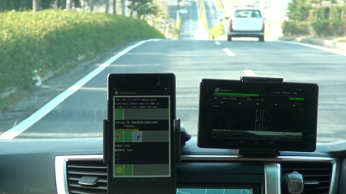
Systems for Lane recognition driving experiment.
We conducted the experiment which investigates whether recognition of the lane of a car is possible by the satellite positioning which uses Quasi-Zenith Satellite and GPS in the last fiscal year.
At this show, the developed application and the receiver used for the experiment are exhibited.
Smartphone/tablet applications, Smartphone/tablet application development services
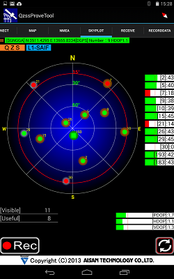
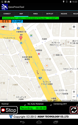
QZSS Prove Tool for Android
We depveloped an data collecting system 'QZSS Prove Tool for Android' for utilization demonstration of Quasi-Zenith Satellite"MICHIBIKI". It's exhibited at this show.
Lifestyle and social systems & leading-edge technologies related products, systems & services, software
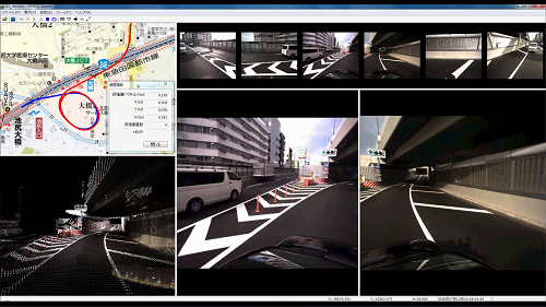
3D Maps using Mobile Mapping System
The mobile mapping system (MMS), developed by Mitsubishi Electric Corporation, can identify the position of a vehicle on which the system is mounted, to a GPS accuracy of within 10 cm when this vehicle is driven on a road without any traffic restrictions. This system automatically creates images of the perimeters of the road, as well as 3D pointcloud-data with a relative accuracy of 1 cm, using a 360 degrees camera and a laser scanner mounted on top of the vehicle.
MMS is used in various fields like those of public survey and infrastructure management, such as management of roads,along with the fields of 3D city map production and disaster prevention.
Furthermore, case examples in the ITS industry for cars include numerous works performed on behalf of research institutions, with a track record for obtaining basic data for car navigational systems, as well as the preparation of VirtualReality data based on data for laser point groups measured by the MMS, that of data for highly accurate drive simulators and road gradient data measurements, and that of maps for safe driving support.
3D maps, currently in use for car navigational systems, are limited to providing the current position and a route map to the destination. If, in addition to these, the vehicle is made capable of recognizing relatively detailed 3D road information, then it will be possible to respond to new needs such as support for safe driving or even automatic driving.
![]()


- 10.11(sat)makuhari messe")